Save Red Rock is always on the lookout for threats to the Rural character of the Red Rock Canyon National Conservation Area. Check out the latest in our efforts.
What You Can Do
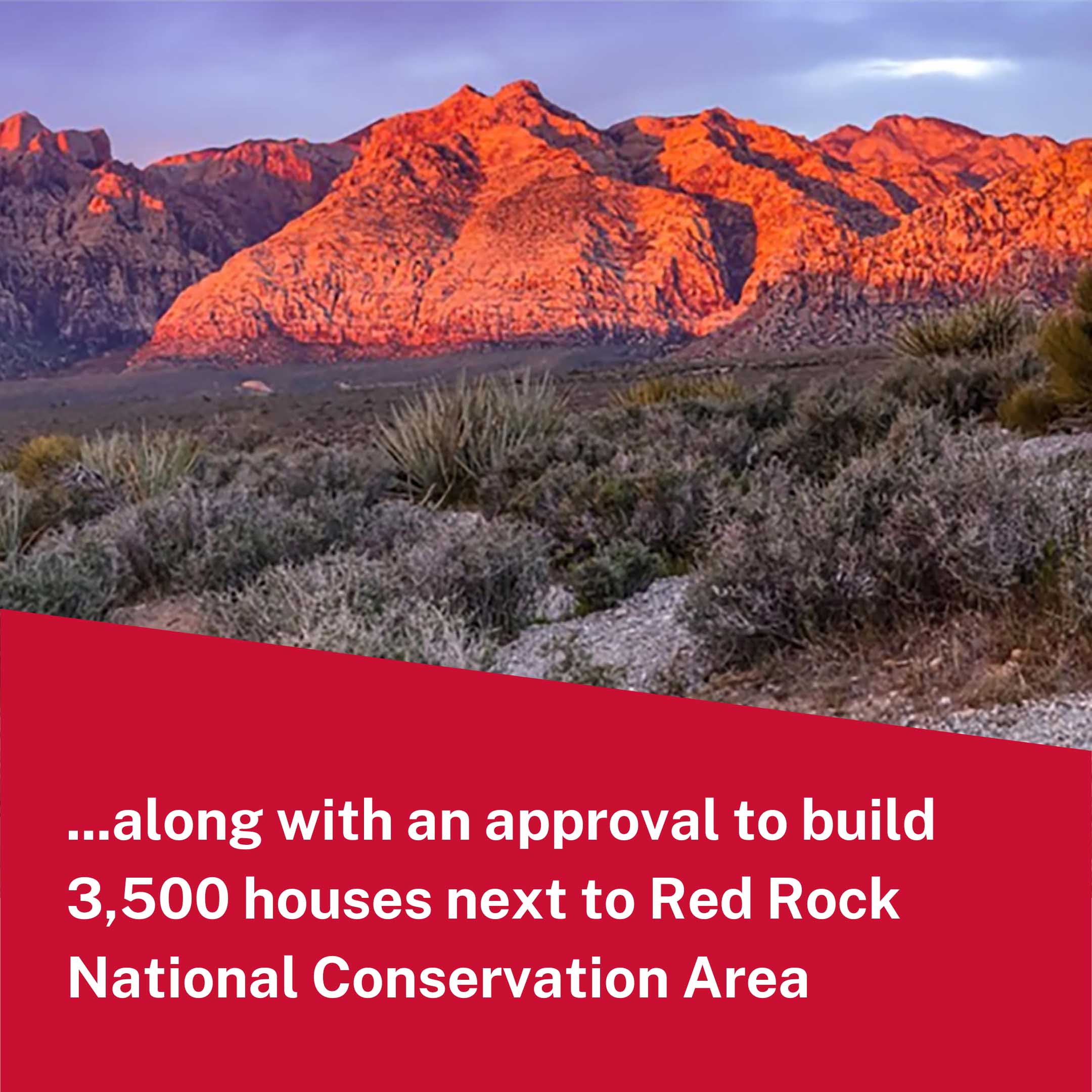
On Tuesday, June 18, 2024, Clark County Commissioners approved a settlement agreement to resolve litigation between Gypsum Resources, LLC and Clark County. The Save Red Rock team is maintaining its commitment to participate in the public process at every juncture possible. If you would like to help, here’s what you can do. If you have not already, please sign the petition to Keep Red Rock Rural and share with everyone you know.
From Our Founder: Our response to the July 3, 2024 Zoning Commission Meeting
When Gypsum Resources purchased 2,400 acres of land on Blue Diamond Hill in March 2003, that land was zoned “Rural”. We all know that this precious plot sits adjacent to the nation’s very first National Conservation Area, and the jewel of Southern Nevada, Red Rock Canyon. For the past 20 years, Save Red Rock has joined the general public and elected officials in imploring the developer to comply with the existing law and simply build what he bought. In that world, we’d have a sustainable amount of new housing, and manage to preserve the safety, serenity and sensitivity of the Public Lands that people, plants and animals rely on.
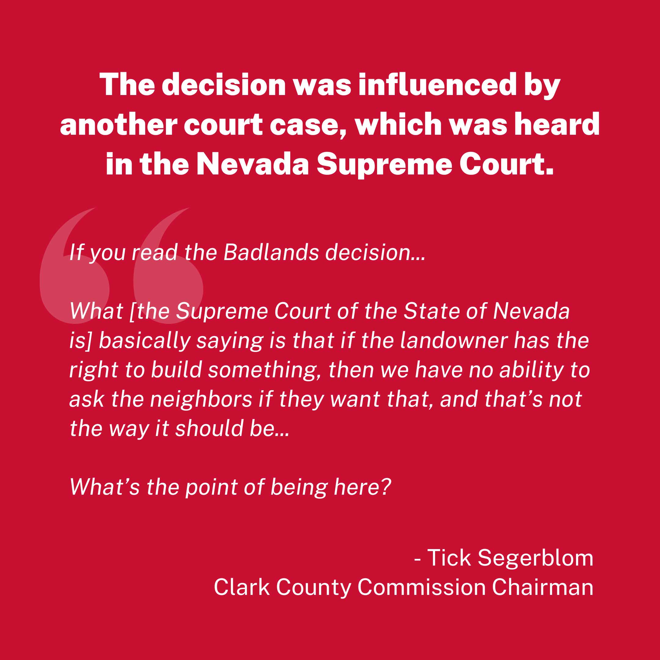
Over the course of two decades, whenever lawmakers or community stakeholders tried to uphold the Rural zoning restrictions, the developer responded with aggressive litigation, strong-arming his way into obtaining waivers and special conditions. Today marks another one of those moments.
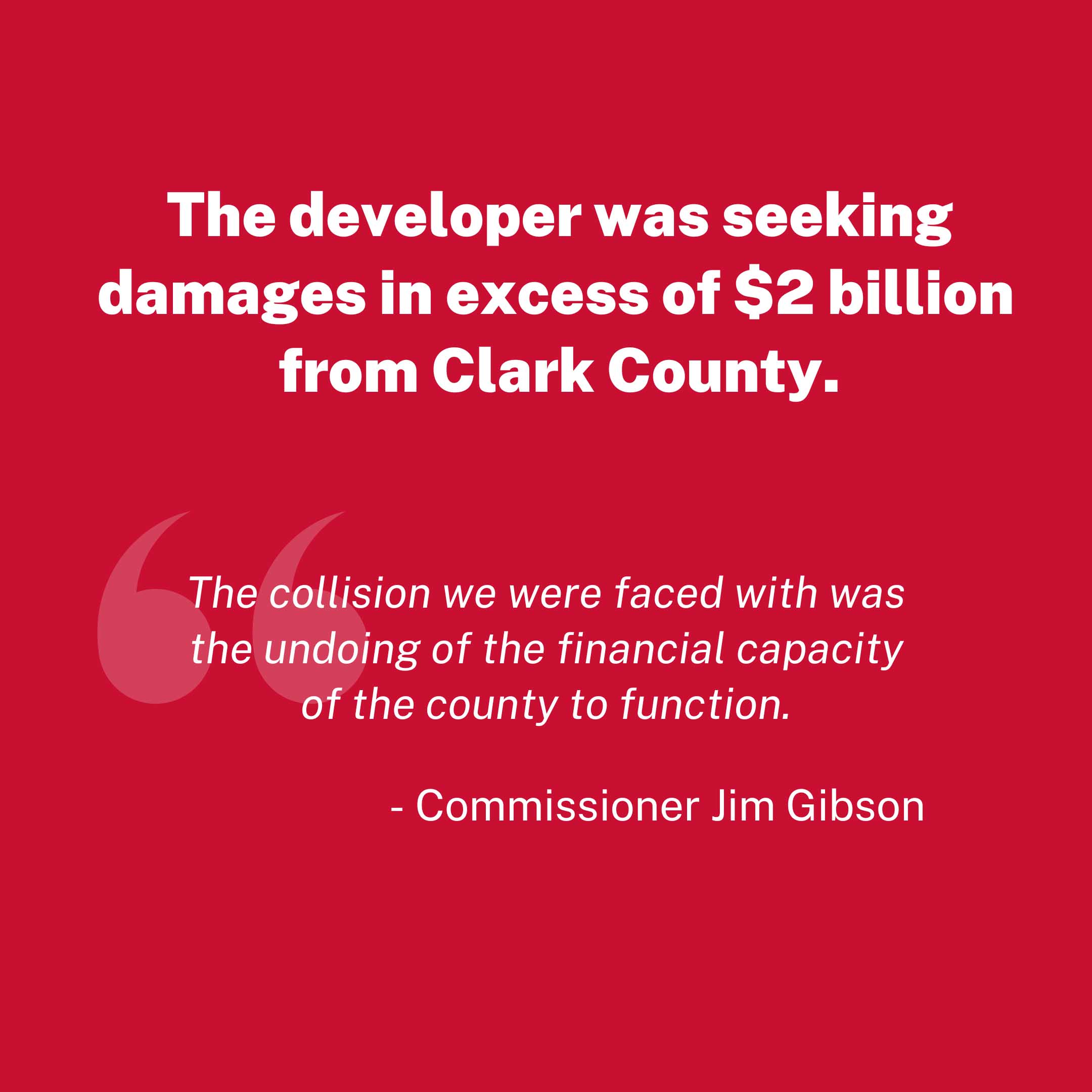
Save Red Rock is committed to preserving the sanctity of Public Lands, and of holding development to rural standards that take into account the environmental sensitivity of this space. We are heartbroken to witness this stage of the process, where the county has been backed into a corner, under the pressures of corporate greed, and is seemingly willing to change Land Zoning and Land Use for the benefit of one company, but at at the expense of millions of visitors and over 53,000 citizens who signed a petition to “Keep Red Rock Rural.”
We understand how the world works, but we will continue to show up and comment on record, and work towards the enforcement of the rural zoning or environmental protections whenever possible.
What Happened?
Click here for a quick overview of the issue as it stands today:


View a quick summary of what transpired:
What’s Next for the Gypsum Resources Development
June 21, 2024
On Wednesday, July 3, 2024, Clark County Commissioners will be reviewing the Development Agreement for the Master Plan. The Development Agreement contains all of the details of the proposed development including supporting documents. Commissioners will be finalizing the details of this plan as part of the Settlement Agreement that was approved at Tuesday’s meeting. If you’d like to review the documents, they are linked below.
The Save Red Rock team is reviewing the details of this agreement and will speak at the commission meeting. If you’d like to assist, please contact us.
Official Documents
July 3, 2024 Zoning Commission Agenda
Development Agreement (Item 48)
Right of Way Application to the BLM
Development Agreement Exhibits
Exhibit A: Signed Settlement Agreement
Exhibit B-1: Assessor’s Parcel Numbers
Exhibit B-2: Legal Description
Exhibit C: ROW Application to BLM
Exhibit D: Title 30 of the Clark County Code dated April 2010
Exhibit E: Concept Plan
Exhibit F: Development Guide
Exhibit G: Land Use Plan
Exhibit H: Master Water Study
Exhibit I: P-C Zoning
Exhibit J: PFNA
Exhibit K: Specific Plan
Exhibit L: Statistical Summary
Exhibit M: Master Parks and Public Facilities Plan
Save Red Rock’s Response to The Settlement Agreement
June 18, 2024
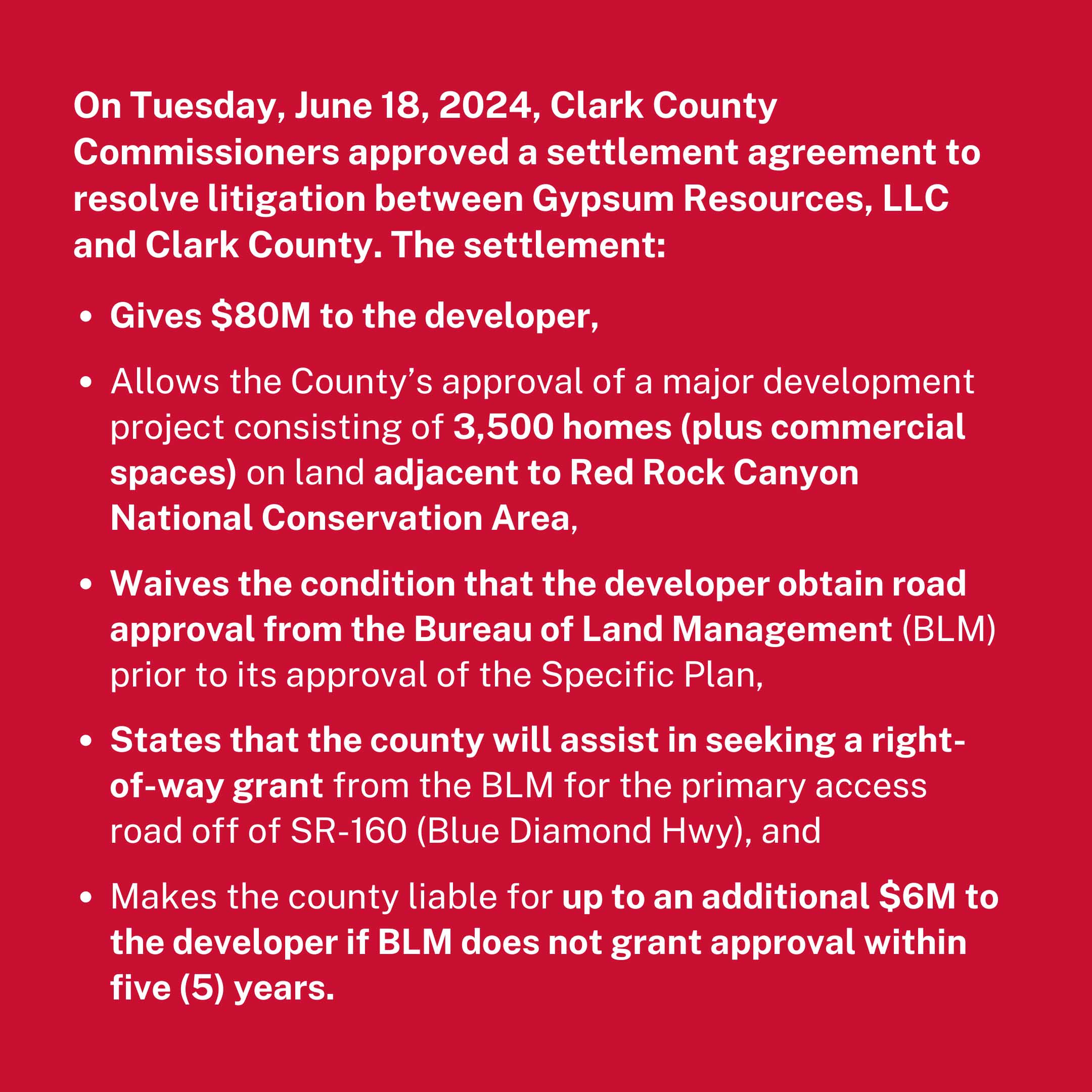
On Tuesday, June 18, 2024, Clark County Commissioners approved a settlement agreement to resolve
litigation between Gypsum Resources, LLC and Clark County. This agreement agrees to:
- Pay $80 million to Gypsum Resources, the developers of a proposed housing neighborhood on Blue Diamond Hill;
- Allow Gypsum to develop a MAJOR PROJECT of 3,500 houses (as compared to the previously applied-for 5,000 houses);
- Waive the condition that the developer obtain road approval from the BLM prior to approval of the Specific Plan;
- Seek a right-of-way grant from the BLM for the primary access road to SR 160 and pay up to an additional $6 million to the developer if BLM does not grant approval within five years.
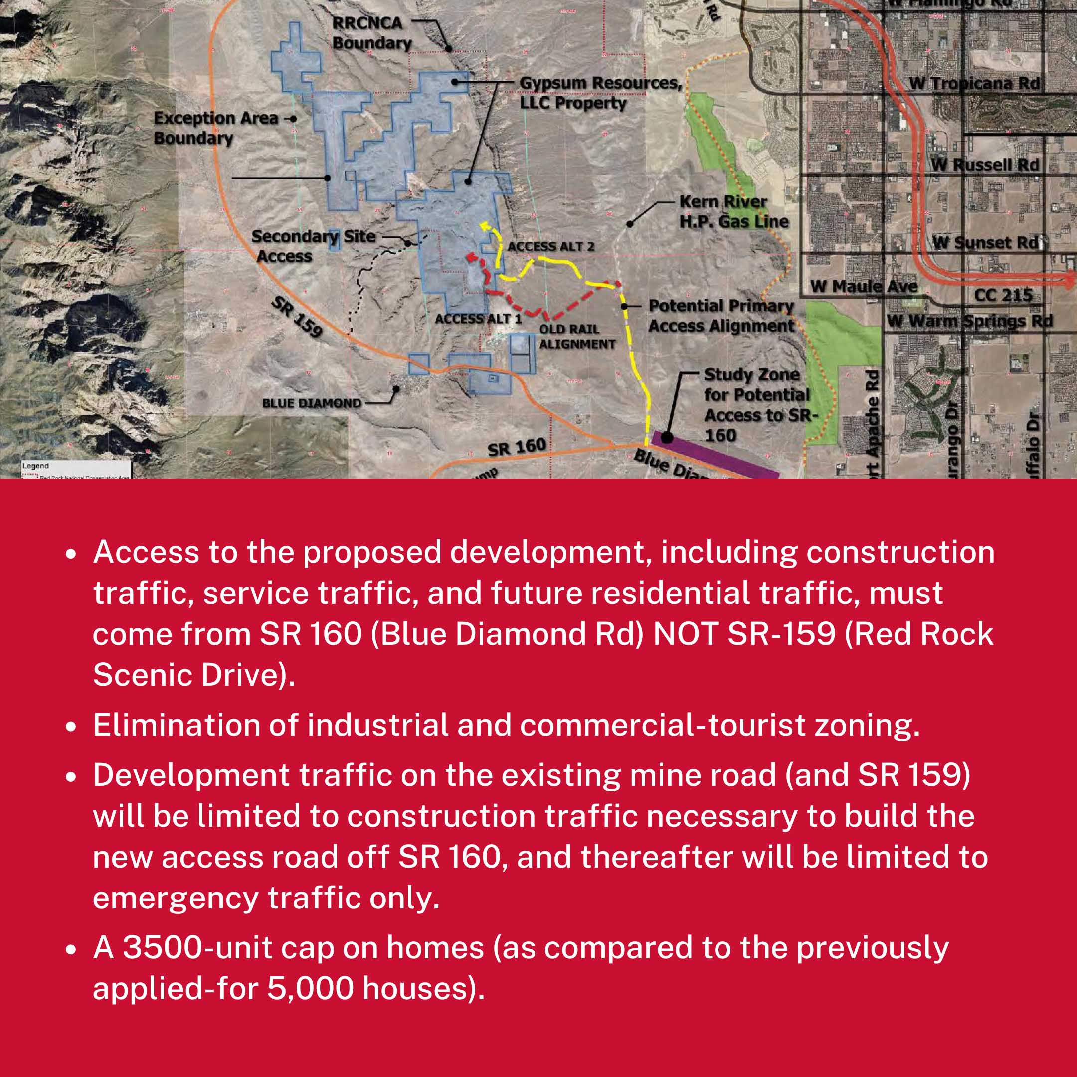
The settlement also solidifies some important restrictions, including:
- Access to the proposed development, including construction traffic, service traffic, and future residential traffic, must come from SR 160.
- Elimination of industrial and commercial-tourist zoning.
- Development traffic on the existing mine road (and SR 159) will be limited to construction traffic necessary to build the new access road off SR 160, and thereafter will be limited to emergency traffic only.
- A 3500-unit cap on homes.
This is one battle in an ongoing war, and we are ready to continue the fight. We must stay vigilant on all levels: county, state, and federal. We are consulting with experts in the legal and conservation fields to consider our next steps. We will keep you informed every step of the way.
We had over 52,000 people sign the petition, email, or call the commissioners in support of Red Rock. Thank you for coming out and showing your support! Your voice matters!
Updates
Media Coverage
Past Campaigns
Save Red Rock has fought to protect the canyon on several fronts, with the community efforts resulting in many significant victories over the years, including lowering the speed limit on the scenic byway, creating safe 8-foot wide bike lanes, safety fencing for the wild burros and mustangs near the highway, and more accomplishments that can be found in our accomplishments page. Currently, Save Red Rock is fighting to KEEP RED ROCK RURAL, to preserve the rural character of the canyon, and to keep out future high density and commercial developments that would adversely impact the experience. Save Red Rock is working to notify people of the current threat of a zone change proposal in the canyon from rural to high density development that county commissioners will vote on soon. (See take action page.) If commissioners change a developer’s rural zoning to high density, he proposes to build a city of over 3,000 residents, businesses, and commercial institutions in Red Rock Canyon.
Top ways you can help:
- JOIN AND SHARE ON SOCIAL
- SIGN THE PETITION (or share it if you’ve already signed it)
- SUPPORT THE CAUSE to help #SaveRedRock
Hear Both Sides of the Issue:
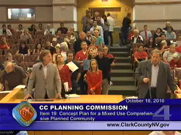
The developer’s presentation is at minute 0:20:00 and goes for about 40 minutes. The public response begins at: 1:02:15, starts with an adorable girl who fought her way to the front of the line to testify of her love of Red Rock (I vote for her!), proceeds with about 90 minutes of public testimony (everyone with different concerns, everyone with the same love of Red Rock), and ends with a plea to not approve this concept because you can’t bring back the character of Red Rock once this has been developed and you can’t unscramble the egg. click to see the video
See developer’s proposed plan and location map in this video:
The Threat
What would allowing Southern Nevada’s third largest city to be built in Red Rock do?
- allow doughnut hole development miles from the nearest infrastructure
- favor a single developer over the public interest (of over 20,000 in opposition to this zone change)
- change the rural character of the canyon
- penetrate the mountain that blocks the canyon from the city, with another city
- introduce the congestion, haze, noise, and traffic that accompany high density development
- flood the dark sky in the canyon with light pollution from thousands of headlights
- cost taxpayers millions to maintain the infrastructure and pump the water 1000 feet up the hill
- impact and endanger tourists and locals seeking to enjoy the natural beauty of Red Rock Canyon with increased traffic volume and disparity
- impose an additional 10-15,000 cars each morning and night from their proposed 6 lane highway to the 4 lane SR 160
- choke the already-congested 2 lane corridors in the Southwest and Mountain’s Edge areas, such as Fort Apache, Durango, Buffalo, and Rainbow
- penetrate 2 major open space reserves, Arden Ridge Open Space and the Southwest Ridge Recreation Area
- directly overlook Red Rock Canyon’s only campground
- forever change the Las Vegas sunset view and natural skyline
- violate the Clark County Title 30 guideline to “correspond with the character and physical limitations of the land”
- violate the Clark County Title 30 guideline to “encourage the most appropriate use of land throughout the county”
- violate the Clark County Title 30 guideline to “protect existing neighborhoods and communities, including the protection of rural neighborhoods”
- violate the Clark County Title 30 guideline to “otherwise further the general prosperity, health, safety, and welfare of the community”
- create liability for the county with concurrent mining, building, and residential conditions
- violate the 2014 Clark County Comprehensive Master Plan provision that “proposed developments be compatible with adjacent land uses”
- violate the 2014 Clark County Comprehensive Master Plan provision that “discourages urban sprawl”
- violate the 2014 Clark County Comprehensive Master Plan provision that “encourages new development to be around existing or future transportation corridors”
written by Trent Billingsley and Heather Fisher, Nov. 17, 2016
The Solution
A PERMANENT SOLUTION? We have dream — it is a long shot, but a “conservation easement” that could preserve lands surrounded by the Red Rock NCA once and for all. Learn more about the Conservation Easement ultimate solution and tell your County Commissioners to give the Nature Conservancy and others time to study this option.
Conservation easements protect land for future generations
- A conservation easement selectively targets only those rights necessary to protect specific conservation values, such as subdivision and high density development, and is individually tailored to meet a landowner’s needs.
- There is no one-size-fits-all conservation easement. Each one is individually tailored to meet conservation objectives and the needs of the landowner, such as the need to continue to derive income from the land through mining, at the same time potentially providing the owner with tax benefits.
- Because the land remains in private ownership, with the remainder of the rights intact, an easement property continues to provide economic benefits for the area in the form of jobs, economic activity and property taxes.
- A conservation easement is a legally binding agreement on the land in perpetuity. A conservation easement is legally binding, whether the property is sold or passed on to heirs.
- The rights conveyed in a conservation easement, such as the right to subdivide, have been established over two decades of case law as having real value.
- Conservation easements do not mean properties are automatically opened up to public access unless so specified in an easement.
- 3.2 million acres are currently held under conservation easement by the Nature Conservancy.
- All information from The Nature Conservancy website.

